

Memphis Regional Intermodal Facility
Project Data Summary Sheet
Project Location
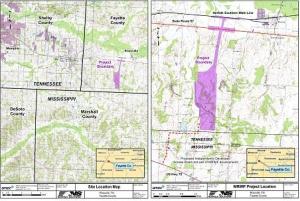
Memphis Regional Intermodal Facility (IMF) in Fayette County near Rossville,
Tennessee.
General Project Description
Memphis Regional Intermodal Facility will be a rail terminal for transferring
freight from one transportation mode to another, in this case between trains and trucks,
without handling of the freight itself when changing modes. It is a large (approximately
7,000 feet long by 2,400 feet wide) parking lot where the rail to truck and truck to rail
modal containers are transferred. The IMF will assist in addressing projected future freight
transportation needs, alleviating transportation bottlenecks and optimize shipping
efficiencies between the Memphis region and the Northeast U.S.
Project Purpose
The primary purpose of the proposed Memphis Regional IMF is to meet current
and future demand for intermodal (rail/truck) transportation in the Memphis region.
Norfolk Southern Railway Company (NSR) will build and own the facility. Its location
relative to projected future growth in the Memphis area is a critical component to satisfy
the project’s purpose. To meet the IMF’s operational requirements, the following main
components needed are:
?? Tracks connecting the Memphis Regional IMF site to the NSR mainline
(preferably without any at-grade crossings)
?? Six 4,000-foot long pad tracks
?? Support yard with 34,500 feet of track
?? Paved areas for the parking of up to 2,177 trailers and containers on chassis
?? Administration, maintenance, and operations buildings
?? Equipment maintenance pad and other related facilities
Traffic
The roadway vehicle traffic will enter and exit the IMF through an independently
developed access road (currently under construction) to U.S. Highway 72 in Mississippi.
The 2009 average daily traffic (ADT) is approximately 11,200 vehicles per day (vpd).
The 2015 ADT for the proposed site is expected to generate approximately 1946 vpd
(1668 truck & 278 vehicle trips).
Alternatives
Alternatives to be considered in the environmental document will include the No-
Build and the Build Alternative, avoidance, mitigation, and environmental enhancement
alternatives for the Build site. The No-Build Alternative will mean that the proposed facility will not be constructed and existing NSR facilities in the area will continue to
operate at current capacity.
The Build Alternative is located approximately 1.5 miles south of State Route
57 and 0.5 mile west of Knox Road near Rossville (Attachment 1). The proposed
IMF would encompass approximately 570 acres, including an approximately 1.6-mile
long, 200-foot wide right-of-way for lead tracks coming from the NSR mainline,
which runs parallel to and north of State Route 57 (Attachment 2). The connection
track corridor would include a grade separation at State Route 57 and a loop track at the
south end of the facility for trains to reverse direction. Avoidance, mitigation, and
environmental enhancement alternatives will be considered during the study and analysis
phase of the NEPA process.
Summary of Environmental Issues
As issues are identified through the NEPA process, additional study and
assessment will be considered for the Project.
Land Use
Most of the land within the project boundaries was previously disturbed
and consists of both forested (mixed hardwood) and non-forested (hay fields)
areas. The site consists of rolling hills and varies in elevation from approximately
350-400 feet above mean sea level. Surrounding land areas may be categorized as
forested, rural residential, and agricultural.
Air Quality
Air quality effects will by analyzed for the affected study area, as well as
emissions impacts of the transfer of freight from truck to rail. The results of these studies
will be analyzed to determine the project impacts on the air quality of the area.
Noise Evaluation
Noise studies will be conducted on the project. The results of these studies will
be analyzed to determine the impact of the project on noise sensitive receptors.
Hydrological Impacts
Construction of the project will likely impact streams in the area. The location
and design of the project will consider impacts on these features and on the floodplains in
the area and will be constructed in accordance with Executive Order 11988 and all local
and federal regulations. In accordance with applicable law, mitigation of stream and
wetland impacts will be including in the NEPA analysis and is anticipated as a condition
of applicable permitting requirements.
The project will be designed and constructed to minimize harm to the streams and
environmental resources. During the construction of the project, strict adherence to all applicable provisions of TDOT’s Standard Specifications for Road and Bridge
Construction and Best Management Practices will be followed.
Ecological Impacts
Detailed terrestrial and aquatic studies will be conducted to determine the
project’s impact on the ecological environment. Studies will be done to determine the
presence of any endangered or threatened species or unique wildlife habitat that could be
affected by the construction of the project or its operation. Attempts will be made first to
avoid and minimize ecological impacts. If avoidance of adverse impacts is not possible,
then mitigation measures will be developed to address impacts.
Cultural Impacts
Historical and Archaeological studies will be done to determine if there are any
sites or properties in the project impact area eligible for, or included in, the National
Register of Historical Places. The studies will determine if the proposed project will
affect any sites or properties of significance in the area. Avoidance and mitigation efforts
will be evaluated as appropriate for impacts that may occur to these sites or properties.
Farmland Impacts
Studies will be done to assess the project impacts on farmland or farmable land.
A Farmland Impact Rating Form will be sent to the Department of Agriculture for their
input. The results of these studies will be analyzed to determine any project impacts on
farmlands.
Socioeconomic Impacts
Analysis will be done to assess any project socioeconomic impacts including
economic benefits to the region.


